Table: Accuracy of the various solutions estimated in 2002.
1. Introduction
2. Report of the International Earth Rotation Service
3. Report of the International VLBI Service for Geodesy and Astrometry
4. Report of the Working Group Precession-Nutation
5. Report of the Working Group High Frequency and Sudden Variations in Earth Orientation
6. Reports from Individual Institutions
The triennial report of Commission 19 for the period 1999-2002 includes the report from the international services supported by the Commission and Working Groups of the Commission and contributions from individual institutions involved in Earth rotation studies. References for publications related to the activities discussed in the following report are being made available on the Commission website : http://syrte.obspm.fr/iaucom19/.
During the triennium 1999-2002, a complete reorganization of the International Service in charge of monitoring Earth rotation has taken place. Such a reorganization has been accompanied by significant improvements in both theory and observations of Earth rotation and by the preparation of the implementation of the IAU Resolutions 2000. These resolutions, which will become effective on January 1, 2003, imply the adoption of a new precession-nutation model (IAU 2000), of a new celestial pole (the Celestial intermediate Pole) and of a new transformation between the terrestrial and celestial systems which defines UT1 as directly proportional to the Earth Rotation Angle. Most of the results obtained during this period have been derived from a combined use of models and observations. This has for example significantly improved the model for the precession- nutation of non-rigid Earth and the understanding of the influence of the atmosphere, oceans and core on length-of-day changes and on the excitation of Chandler wobble.
Following the Call for Participation in the new IERS in the end of 1999, the review of the proposals by a Review Board and its recommendations to the Directing Board, the new structure of the IERS began operation on January 1, 2001.
The main novelties are: (i) the previous Sections and Sub-Bureaus of the Central Bureau are now autonomous components within the IERS and are called Product Centres, (ii) the Central Bureau moved from Paris to Frankfurt am Main in Germany and has now primarily administrative functions, (iii) new elements of the structure are Combination Research Centres, ITRS Combination Centres and the Analysis Coordinator, (iv) external services like IGS, ILRS and IVS serve as Technique Centres for the IERS.
The central IERS web site www.iers.org, which became operational on 1 January 2001, provides information on IERS and gives access to all other IERS web sites as well as to related sites.
During 1999 and 2000, the former Central Bureau in Paris performed the general management and daily coordination of IERS activities involving the relationships with users, the archival and dissemination of products, IERS gazettes and relevant documentation and information. During the course of 2000 these Central Bureau activities were smoothly transferred from Paris Observatory to the Bundesamt für Kartographie und Geodäsie (BKG), located in Frankfurt am Main, Germany.
The Analysis Coordinator is responsible for the long-term and internal consistency of the reference frames and other products, and also for ensuring the appropriate combination of the Technique Centres products into the single set of official IERS products and their archiving.
The IGS, which began routine operation on 1 January 1994, is committed to provide the highest quality data and products as the standard for global navigation satellite systems. In this context the IGS offers a large number of consistent products. Since December 2001 all IGS products are based consistently on the IGS Reference Frame realization of the ITRF2000. Pilot Projects have been launched to develop new products and services.
The ILRS, established in 1998, is responsible for the coordination of SLR/LLR missions, technique development, operations, analysis and scientific interpretation. With the development of (an) official ILRS product(s) and the quality control issue (of observations and products) in mind, the Analysis Working Group has initiated a number of pilot projects that can be considered as the focal point of the ILRS analysis activities.
IVS was inaugurated in March 1999 and has been accepted as a Service of IAG and IAU. During its first three years of operation, IVS initiated regular product delivery via its Data Centres, established its own observing programs, held scientific and technical meetings and workshops, and published Annual Reports and Proceedings. (See also the IVS report below.)
In 1999, following the IERS reorganization, it has been decided to create a DORIS Pilot Experiment. This Pilot Experiment gave time to all groups to coordinate and improve their operationability in order to create on the long term an International DORIS Service (IDS).
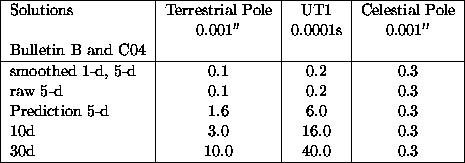
The IERS Earth Orientation Centre (formerly: EOP Section of the Central Bureau) located at Paris Observatory collects and makes available to the scientific community observations of Earth Orientation variations derived from the various geodetic techniques (LLR, SLR, GPS, VLBI and DORIS). The analyses are performed daily to fulfil the requirements of users, operational and scientific. The products derived include combined standard solution for polar motion (x,y), Universal Time (UT1-UTC, UT1-TAI), nutation offsets (dpsi, deps). Much improvements were done in the combination procedure in the recent years. The following table gives the accuracy reached in the determination of the operational Earth Orientation Parameters in 2002:
Table: Accuracy of the various solutions estimated in 2002.
Other series, based on normal points solutions given at various time intervals, are also proposed to users, i.e. C 02 (5-day intervals), C 03 (one-day intervals). These series are mutually consistent. Recently there were new developments in the normal point series C 02 and C 03 in which the estimation of the solution given at the central dates of the n-day interval is made using a least-square fit for all EOP components. Although the L2 estimation has been extensively used for data analysis, it has some drawbacks linked to problems of ill-conditioning and in the non-detection of outliers. Alternative methods based on robust estimators like M-Huber can be used. These estimators are a generalization of both the L1 and L2 class. They have been implemented in our analyses and are now currently used.
Long-term analyses of the Earth orientation in space and maintenance of long period EOP series are also currently done on a yearly basis. EOP(IERS) C 01 is a series of the Earth Orientation Parameters given at 0.1 year interval from 1846 to 1889 and 0.05 year interval from 1890 until now. The C 01 series is used to monitor the consistency between both celestial and terrestrial reference frames with respect to the EOP System. Other publications concern DUT1 time dissemination (Bulletin D) and leap second announcements (Bulletin C).
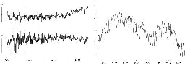
Figure: Left: Celestial pole offsets (in longitudexsin(obliquity) (top),
obliquity (bottom) ; Right: Variations in lod with zonal tides removed
The U.S. Naval Observatory (USNO) serves as the Rapid Service / Prediction Center
for the determination of the quick-look Earth orientation parameters. The
combination algorithm is based on a weighted cubic spline with adjustable smoothing
fit to the contributed observational data (McCarthy & Luzum, 1991a). Polar motion
predictions are based on the extrapolation of an annual and semiannual ellipse and
a Chandler circle fit to the previous 400 days of observed values of PM-X and PM-Y,
and UT1-UTC predictions are based on a simple technique of differencing, for details
on both these techniques see McCarthy and Luzum (1991b). The prediction of d ![]() and d
and d ![]() is based on the KSV 1996
is based on the KSV 1996 ![]() model (McCarthy, 1996). Predictions of
UT1-TAI up to 2010 are derived using a prediction algorithm similar to that employed
in the Bulletin A predictions of UT1-UTC.
model (McCarthy, 1996). Predictions of
UT1-TAI up to 2010 are derived using a prediction algorithm similar to that employed
in the Bulletin A predictions of UT1-UTC.
Comparisons of the Rapid/Prediction Center PM-X, PM-Y, and UT1-UTC daily products to the IERS C04 series indicate that the standard deviations of the differences between the solutions are 0.16 mas, 0.18 mas, and 0.076 ms, respectively. Similarly, the standard deviation of the differences between the Bulletin A daily solution and the C04 predictions at 10 days into the future are 3.99 mas, 2.93 mas, and 1.887 ms for PM-X, PM-Y, and UT1-UTC, respectively. For additional comparisons of Rapid/Prediction Center Bulletin A Rapid Solutions (Twice Weekly), Bulletin A daily solutions, and the center's running solution to IERS Bulletin B and C04 as well as a list of data used in and recent improvement to Rapid Service/Predictions Center's products, see USNO's report below.
The Convention Centre is provided jointly by the U.S. Naval Observatory (USNO) and the Bureau International des Poids et Mesures (BIPM), who are working on the new edition of the IERS Conventions. This has been slightly re-organized with respect to Conventions 1996, and numerous updates have been introduced, including the changes brought about by the Resolutions adopted at the IAU2000 24th General Assembly. New versions of chapters and accompanying software are posted on the web as soon as they become available.
The ICRS Centre, which is co-directed by the Paris Observatory and the US Naval Observatory since 2001, schedules to publish a bi-annual technical note starting from the end of 2002, in order to explain in some details the evolution in the maintenance of the Celestial Reference System in two year intervals. This will include a summary of the works which have been done on catalogues, and the results of studies which are currently carried out by the ICRS Centre, as the densification of the ICRF, the evolution of extra-galactic sources with respect to time, and the link between catalogues in various wavelengths.
The main activities of this centre, located at IGN, are: (i) Maintenance of the IERS network. This activity includes update of the IERS network database in terms of new sites and stations, assignment of DOMES numbers, local ties, availability of IERS network information and ITRF products on the web and ftp server, as well as assisting the ITRF users for a proper use of ITRF products; (ii) Data analysis and Software enhancement. With interaction of IERS Analysis Centres (AC), individual solutions from the different techniques are frequently evaluated and tested, in order to improve the individual analyses as well as the ITRF combination. Thus both the individual ACs as well as the ITRF Section regularly test new analysis strategies. This cooperation between the IERS ACs and the ITRF Section is vital for quality control and improvement of IERS products. To achieve this goal, the software package Combination and Analysis of Terrestrial Reference Frames (CATREF), developed by the ITRF Section, is regularly updated and enhanced, (iii) ITRF2000. A great part of the activity was devoted to the preparation of the ITRF2000 solution, published in March 2001. It is intended to be a Standard and densified solution for a wide application community (geodesy, cartography, navigation, etc.), and it is the most dense and accurate frame ever developed, containing about 800 stations located on about 500 sites. It has been achieved by simultaneous combination of positions and velocities using full variance/covariance matrices of the individual solutions provided by the IERS ACs. It includes core stations observed by VLBI, LLR, SLR, GPS and DORIS (usually used in previous ITRF versions) as well as regional GPS networks for its densification (Alaska, Antarctica, Asia, Europe, North and South Americas and Pacific).
The GGFC was established by IERS in 1998 to serve the global geodynamic research community. Eight Special Bureaus (SB) were since established worldwide for Atmosphere, Core, Gravity/Geocentre, Hydrology, Loading, Mantle, Oceans, and Tides. Under GGFC/SBs, the time variation of angular momenta and the related torques, gravitational coefficients, geocentre shift, and global mass loading will be computed for all geophysical fluids based on global observational data, and/or products from state-of-the-art models some of which assimilate such data. The computed quantities, algorithm and data formats are standardized and made available to the scientific research community. The GGFC is coordinated at NASA/GSFC.
The SB for the Atmosphere has continued to collect, archive, make available, and advise on atmospheric information related to global geodetic studies; it is concerned principally with the axial and equatorial components of Earth momentum related to length of day and polar motion, respectively, which are strongly tied to the signature of winds and atmospheric mass. It has records up to several times per day from several of the world's large weather centres. The angular momentum covering over 99% of atmospheric mass, and many of the climate related signatures associated with intraseasonal and interannual variability, such as Madden-Julian oscillations, the El Nino/Southern Oscillation, and the North Atlantic Oscillation have been studied.
The SB for the Oceans (SBO) is responsible for collecting, calculating, analysing, archiving, and distributing data relating to nontidal changes in oceanic processes affecting the Earth's rotation, deformation, gravitational field, and geocentre. The oceanic products available through the IERS SBO web site are produced primarily by general circulation models of the oceans that are operated by participating modeling groups and include oceanic angular momentum, centre-of-mass, and bottom pressure. A subroutine to compute these oceanic products from the output of general circulation models can also be downloaded along with a bibliography of related articles.
The SB for the Core (SBC) focuses on theoretical modeling and observations related to core flow, and on inner core - outer core - mantle interactions. Since its creation in 1998, the SBC has created a web site, which contains documented model data on core flow and core angular momentum and an extensive bibliography. In addition, a description is given of the relevant theories and of the dynamical assumptions used for constructing the flow.
On February 1, 2002, the SB for Loading (SBL) was established to promote, stimulate and coordinate work and progress towards a service providing information on Earth surface deformation and gravity variations due to surface mass loading. The SBL will provide in near real-time a consistent global solution data set describing at least the surface deformation, gravity signal and geocentre variations due to the various surface loading processes.
The ITRS Combination Centres are responsible to provide ITRF products by combining ITRF inputs from the Technique Centres and others. The following institutions established ITRS Combination Centres between 2001 and spring 2002: Deutsches Geodätisches Forschungsinstitut (DGFI), Germany; Geomatics Canada, Geodetic Survey Division; Institut Géographique National, France.
DGFI has computed a combined solution based on individual solutions, which were used by IGN for the computation of the official ITRF2000. A comparison between both ITRS realizations show in general a good agreement. However, for some sites significant differences for station positions and velocities exist.
The Combination Research Centres (CRC), established on 1 January 2001, are responsible for the development of combinations from data and/or products emanating from the different techniques. The centres develop recommended methods, provide detailed descriptions, and make the necessary software available to the Analysis Coordinator. The following institutions maintain CRCs:
An IERS Workshop on the Implementation of the IAU 2000 Resolutions was held in Paris Observatory, 18-19 April 2002. It included detailed presentations and explanations of the contents of the Resolutions, the background reasons for their adoption, associated concepts and implementations as well as answers to specific questions. About 80 participants from 20 countries took part in the meeting. The Proceedings will be printed as IERS Technical Note and are available online through IERS's web site.
IERS issued the following electronic publications:
IERS Bulletins A to D, IERS Gazettes/IERS Messages.
The IVS (International VLBI Service for Geodesy and Astrometry) was established in 1999. One of its objectives is to provide high quality VLBI products including such unique measurements as UT1 and the position of the pole relative to the celestial reference frame. Beginning in December 2000 a combined IVS EOP series became officially available that is rigorously generated from the weekly 24-hr NEOS sessions. The internal consistency between results from different IVS analysis centers for 1999.0-2002.5 is 100-140 microarcsec for X-pole, 60-110 microarcsec for Y-pole, and 3-7 microsec for UT1. The consistency of celestial pole positions is generally 60 microarcsec. In January 2002 the IVS began a unified EOP measurement program. In addition to the NEOS series, which was renamed R4, a second weekly 24-hr series called R1 was instituted with fourfold increase in data rate made possible by Mark IV. The initial R1 data are internally better than R4 in the standard test of baseline length consistency.
The WG whose members are: V. Dehant (Chair), A. Brzezinski, N. Capitaine, O. de Viron, A.-M. Gontier, S. Mathews, D. McCarthy, has been working on three different topics by communicating (email and meetings). Here are the conclusions of the discussions.
- MHB2000 (Mathews et al., 2002), adopted by the IAU in 2000, is based on the REN2000 rigid Earth nutation (Souchay and Kinoshita, 1996, 1997). The non-rigid Earth transfer function accounts for effects from mantle inelasticity, from the largest ocean tides, includes the FCN and FICN resonances, the electromagnetic coupling at CMB and ICB, a prograde annual (S1) atmospheric correction, non-hydrostatic CMB flattening and non-hydrostatic global dynamical flattening, in agreement with the observed precession and nutations; see Mathews et al. (2002); - the effect of an inner core differential rotation rate on nutation is very small but the effect of an outer core differential rotation rate could be above the observation uncertainties; see Huang and Dehant (2002); - concerning diurnal and sub-diurnal nutations, frequently referred to as high frequency nutations, A. Brzezinski has taken the leadership of a sub-group in which an harmonic development of polar motions equivalent to such nutations (due to the lunisolar torque on the triaxial and non-ellipsoidal Earth with frequencies outside the retrograde diurnal band) has been worked out; the results have been computed from a direct integration of the torque equations for the non-rigid Earth and its core or from a Hamiltonian approach, and refer to the conventional intermediate pole (CIP) which was defined by Resolution B1.7 of the last IAU General Assembly; two different computations for the non-rigid Earth were considered in the discussions, one by Mathews and Bretagnon (2002, Proc. JSR 2001) and the other one by Brzezinski (2001, Proc. JSR 2000), Brzezinski and Capitaine (2002, Proc. JSR 2001); the articles describing these theories are in preparation and should be soon submitted for publication in peer-reviewed international journals; a consensus has been reached and final tables have been provided for the IERS Conventions.
- There is a non-negligible effect on the observed nutation from instabilities in the positions of the radio-sources; this is particularly true for the precession and the 18.6 year nutations; see Dehant et al. (2002).
- The atmospheric effects on nutation are not constant and reach the observable level not
only at the prograde annual frequency (corresponding to the diurnal thermal ![]() effect);
see Yseboodt et al. (2002);
- A constant indirect effect of the atmosphere at the major tides (
effect);
see Yseboodt et al. (2002);
- A constant indirect effect of the atmosphere at the major tides ( ![]() ,
, ![]() ,
, ![]() ,
and
,
and ![]() ) frequencies through the ocean is already accounted in the MHB2000 model as the
ocean tidal models assimilate satellite altimetry data. Nevertheless, effects at other
frequencies can reach amplitudes above the observation precision; see Dehant et al. (2002);
- the atmospheric excitation around the annual and the FCN frequencies has a maximum at
a frequency which is variable with time; when the frequency of the maximum is close to the FCN
frequency, the amplitude of the observed FCN free mode is high, and conversely, when the maximum
is far from the FCN frequency, the FCN free mode amplitude is low; see Yseboodt et al. (2002)
and Dehant et al. (2002);
- in the diurnal retrograde band, the mountain and friction torques should (for theoretical
reason) compensate nearly exactly the torque on the ellipsoid; a cancellation has been
shown in the data, but only about 60% of the ellipsoidal torque is cancelled; it is well
known from numerical analysis studies, that the cancellation of large numbers requires a
very high precision for the residuals to be close to the true value. The present
precision in the high frequency atmospheric modeling and in the torque computation is
not good enough to allow such a precise cancellation. This explains probably most of the
discrepancies between the torque and the AAM approach as observed by several studies;
see de Viron et al. (2001).
) frequencies through the ocean is already accounted in the MHB2000 model as the
ocean tidal models assimilate satellite altimetry data. Nevertheless, effects at other
frequencies can reach amplitudes above the observation precision; see Dehant et al. (2002);
- the atmospheric excitation around the annual and the FCN frequencies has a maximum at
a frequency which is variable with time; when the frequency of the maximum is close to the FCN
frequency, the amplitude of the observed FCN free mode is high, and conversely, when the maximum
is far from the FCN frequency, the FCN free mode amplitude is low; see Yseboodt et al. (2002)
and Dehant et al. (2002);
- in the diurnal retrograde band, the mountain and friction torques should (for theoretical
reason) compensate nearly exactly the torque on the ellipsoid; a cancellation has been
shown in the data, but only about 60% of the ellipsoidal torque is cancelled; it is well
known from numerical analysis studies, that the cancellation of large numbers requires a
very high precision for the residuals to be close to the true value. The present
precision in the high frequency atmospheric modeling and in the torque computation is
not good enough to allow such a precise cancellation. This explains probably most of the
discrepancies between the torque and the AAM approach as observed by several studies;
see de Viron et al. (2001).
This Working Group has not been settled yet due to the period of re-organization of the IERS. As it is clear that this topic will be of major importance for the Commission during the future three years, such a Working Group will have to become active for the next triennium for developing the scientific discussions and coordinated work on the topic.
So far the latest solution of Earth Orientation Parameters (EOP) from optical astrometry observations in the interval 1899.7-1992.0, called OA00, was made in 2000. It is based on more observations and slightly modified algorithms than before (Vondrák et al. 2000). The principal changes with respect to previous solutions OA97, OA99 consist mainly in correcting about 20 per cent of the Hipparcos proper motions and merging observations from different instruments at the same observatory to a single series. The results, based on optical observations with 47 different instruments at 33 observatories, were further studied, namely the long-periodic polar motion (Vondrák 1999, 2000, Vondrák et al. 2000) and celestial pole offsets (Vondrák & Ron 2000a,b, Yaya et al. 2000, Ron & Vondrák 2001).
Theoretical and practical aspects of the new precession-nutation model and its agreement with the optical and VLBI observations were considered in (Dehant et al. 1999, Ron 2000, 2002, Vondrák et al. 2000a,b, Vondrák 2002). The comparisons made proved that the observations of both kinds fit much better to the new precession-nutation model IAU2000 than to the older model IAU1980, and the free core nutation was re-confirmed.
In 2000, in consequence with the new organisation of the IERS (Vondrák 2001), the Combination Research Center was created in close cooperation of the Astronomical Institute and the Faculty of Civil Engineering. Its work is covered by newly created Center for Earth's Dynamics Research (Kostelecký et al. 2002). New studies followed, in two different directions. The first one, concerning only the combination of EOP, led to the proposal of 'combined smoothing' algorithm that takes into consideration different accuracy of different techniques in different frequencies (Cepek & Vondrák 2000, Vondrák & Gambis 2000, Vondrák & Cepek 2000). That brought qualitatively new results based on the combination of VLBI and GPS observations, namely in combining UT1 with l.o.d. and celestial pole offsets with their rates (Vondrák & Cepek 2001, Ron & Vondrák 2002, Vondrák et al. 2002a,b). It was demonstrated that using the GPS-based rates improves the solution in the short-periodic part.
Another direction of research is combining particular solutions of different techniques for the simultaneous determination of EOP and station coordinates (Pesek & Kostelecký 2000). From the individual techniques and epochs, the position vectors of the stations are restored in the celestial reference frame and combined to obtain corrected EOP. Transformation parameters to the station coordinates are then derived for each input solution.
Theoretical investigations were mainly dealing with the interactions between ERP and atmospheric phenomena and with low frequency terms in polar motion and lod. Regular observations have been performed with different techniques. In the three years reporting period the SLR station operated on a regular basis (apart from an interruption of several months) with daily tracking of Low Earth Orbit (LEO) satellites, Medium Earth Orbit (MEO) and high one. The number of observed satellites ranges from 2 to 5 per night. In the 12 hours after each session all observed data are pre-processed and downloaded to the central European data bank (EDC) in Munich. The control software has been completely rewritten, moving from the old DOS platform to a new, Linux-based one. Investigations started on the problem of the collocation between different geodetic techniques and the comparison among reference systems based upon SLR, GPS and VLBI solutions. In particular the comparison of SLR and GPS solutions from Glonass satellites, observed with the two techniques in common-view, has been studied. In addition to the IGS GPS station, which is active as fiducial point since 1995, a new GPS+Glonass permanent station came into operation by the end of 2001. Both permanent GPS stations participated in the IGS, IGLOS and, since 2002, EUREF Permanent Network.
The new adopted model of non-rigid Earth nutations (MHB2000, Mathews et al., 2002) has been compared with Very Long Baseline Interferometry (VLBI) observations in order to evaluate its accuracy and to estimate to which extent it can be used in order to constrain Earth interior models.
Two types of limitations have been investigated: imprecision in the modeling of the nutations and errors in the data used. It has been shown that limitations in the modeling are coming from uncertainties about the atmospheric effect which is not at one given frequency (the one solar day or prograde annual period in space) and not constant with time (as assumed by MHB2000), but rather changing with time and at different frequencies corresponding to the seasonal modulations of the one solar day. Oceanic and atmospheric corrections have been evaluated from the ocean and atmosphere angular momentum data and the associated torques have been computed. Limitations in the observation precision also come from the non-stability of the quasar sources used in the VLBI analysis.
The coupling mechanisms between the fluid core and the mantle of the Earth have been studied in order to improve the theoretical nutation models. In addition, the interaction between the large-scale atmospheric phenomena (ENSO cycle, seasonal cycle,...) and the Earth rotation have been analyzed in collaboration with scientist from JPL. In the frame of the IERS, the Special Bureau for the Core hosted at ROB has collected 9 series of core angular momentum data, available now for the Earth rotation community (see IERS/GGFC report). The EUREF GPS permanent station positions and velocities have been evaluated and used in the frame of the ITRF.
A common research project (Sternwarte and Meteorologisches Institut der Universität Bonn, Institut für Meereskunde der Universität Hamburg) was finished in 2000. The topic was the effect of the interactions between oceans and atmosphere on the rotation of the Earth. A natural extension considered the corresponding variation of the gravity field.
A new time series of astronomically determined LOD was constructed and compared with processes in geophysical fluids (Liao, Greiner-Mai). A possible relative inner-core motion was derived from decadal polar-motion variations, and its testability by modern satellite measurements of gravity variations (CHAMP, GRACE) was checked (Greiner-Mai, Jochmann, Barthelmes). Climate cycles in polar motion were interpreted by geophysical excitation mechanisms (Jochmann, Felsmann). Open problems of internal excitation of decadal rotational variations were discussed (Greiner-Mai et al.). The contribution of Geodetic Institute Potsdam to the ILS was historically reviewed (Höpfner). Different sources of seasonal LOD variations were considered (Höpfner). Filtering of space-geodetic time series of polar motion revealed parameters of the Chandler and annual wobbles as well as parameters of shorter periods (Höpfner). The oceanic contribution to seasonal polar motion was studied using different ocean circulation models (Wünsch). Several soil moisture models were analyzed in their relation to seasonal polar motion (Wünsch).
The Main Astronomical Observatory in cooperation with other institutions has established new SLR station (in Lviv) and GPS stations (in Poltava and Mykolayiv) which were included to ILRS and IGS. The construction of the GAO UA series of compiled catalogues of radio source positions has been continued by Ya.Yatskiv and his collaborators in 1999-2002 (Kinematics and Physics of Celestial Bodies, 2002, Supplement 3, 55-58).
The different activities which have been developed for service or research purposes are described below:
EOP Service: everyday computation of SLR and VLBI-24h EOP series have been continued. Everyday computation of EOP from VLBI Intensives and GPS observations was started in 2000 and 2001 respectively. As a result, all four main EOP series: VLBI 24h, VLBI Intensives, GPS, SLR, are routinely computed at the IAA. Operative solutions are submitted to the IERS daily. Final EOP series are: VLBI 24h 1980-2002, VLBI Intensives 1984-2002, SLR 1983-2002, GPS 2000-2002. All series are used in the IERS combined solutions.
Computation of station coordinates: station coordinates from VLBI observations are computed daily along with EOP and series of stations coordinates from GPS observations are computed from EUREF observations as result of re-processing of weekly the EUREF solutions provided by CODE/BKG. Station coordinates solutions for Baltic Sea Level campaign were also provided.
Computation of radio source coordinates: several radio source catalogues were submitted to IERS in 1999-2000.
Comparison and combination of EOP series, station and radio source coordinates: basic software for comparison and combination is being developed and used in the framework of regular EOP service activity and scientific researches. Regular comparison of EOP series is being performed for investigation of systematic errors of IAA and other EOP series. In particular, this comparison allow us to detect and fix some problems with OCCAM package used for processing of VLBI observations. This software is also used for control of the IAA EOP series.
New strategy for computation of the IVS combined EOP series was proposed and submitted to the IVS Analysis Coordinator. New method of computation of operative UT1 series on basis of combination of VLBI and satellite data was moreover developed and advanced strategy for combination of EUREF weekly solutions is under development. Extensive comparison was performed of VLBI EOP results obtained with two program packages OCCAM and ERA and two observational programs NEOS-A and CORE-A. Substantial systematic differences between these series were found.
A possibility of computation of independent EOP series on basis of the VLBI, GPS and SLR EOP series computed at the IAA is under investigation and combined VLBI-GPS solution for European baseline lengths is obtained.
Investigation of nutation: comparative analysis of the VLBI and IERS combined nutation series was performed for investigation of systematic differences between them. Corrections to precession parameters were obtained from analysis of four VLBI EOP series. Further investigations are planned.
The main scientific developments during the last triennium are the following:
The presence of subharmonics of the Chandler period (1.2 years) and superharmonics of the lunar period (18.6 years) in the ENSO and QBO spectra was detected. It was revealed that the power spectrum of the QBO and the series coordinates of the pole have a similarity coefficient 2.
A model for the nonlinear nutation of the Earth-ocean-atmosphere system was constructed. In this model, the ENSO, acting at frequencies of combinational resonances, excites the Chandler wobble of the Earth's poles. At the same time, this wobble and long tide interacts with the nutation motions of the atmosphere and World Ocean.
The monograph "Physics of the Earth's Rotation Instabilities" was published in 2002 (in Russian). The results of the investigation of the nature of Earth rotation instabilities and related geophysical processes are generalized in this book.
The specific features of the coupling between Earth and Moon enable us to treat the Earth-Moon system as a binary planet and oscillations in the Earth-Moon system then obey the basic dynamical principle of constrained systems. Using a model of the basic features of the real Earth-Moon system, a proof of the appearance of eigenfrequencies in the constrained system has been derived. In this model, the period of the proper oscillations in the coupled Earth-Moon system are T1=434.8 days and T2=345.9 days (Kurbasova & L.V. Rykhlova, 2001; Kurbasova et al. 2002). A model for the rotation of the deformable Earth about the center of mass taking into account the barycentric distance of the Earth-Moon system was constructed which forms a basis for the development of a high-accuracy theory of the Chandler polar oscillations and comparison with astrometric observations. Refined analytical expressions for the frequencies corresponding to the Chandler motion of the pole and the diurnal rotation of the deformable Earth are derived. The trajectory of the Chandler polar motion derived via numerical modeling is in qualitative and quantitative agreement with experimental data from the IERS (Akulenko et al. 2002).
The Earth's model consisting from the solid inner core (SIC), the fluid outer core (FOC),
the mantle and the atmosphere was used to build new nutation theory (ZP2001).
Magnetic coupling at the core-mantle and inner core boundaries and
viscosity of the FOC were incorporated in theory. The effects of mantle anelasticity,
ocean loading and currents were added as increments to the compliance
parameters. New nutation series was obtained by convolution of the rigid Earth
nutation series RDAN97 with the transfer function. The resonance strengths
and frequencies of transfer function were calculated on base of our Earth's
model. The obtained frequencies are complex quantities whose imaginary components
are negative; in our model these components depend only on the magnetic-viscosity
components which means that the adjustment procedure yields a non-physical model of the
Earth structure. In order to overcome this problem some energy generation processes were
analyzed. We considered the super-rotation of the SIC at first. As our calculations
show, it is possible to fit the theoretical and observed nutations with rms
error of 0.20 mas. It is possible to get positive imaginary components of the normal mode
frequencies, but differential rotation of the SIC has to be very large ( ![]() degrees/day). The second hypothesis is the existence of the generation processes in the
FOC. The excitation function for the FOC was built as it was done for the
atmosphere. The new nutation series corresponds the physical model of the Earth.
The rms of the post-fit residuals observed and theoretical nutations in
longitude and obliquity are equal to 0.25 mas and 0.23 mas, respectively, the FCN model being not
included in the series.
degrees/day). The second hypothesis is the existence of the generation processes in the
FOC. The excitation function for the FOC was built as it was done for the
atmosphere. The new nutation series corresponds the physical model of the Earth.
The rms of the post-fit residuals observed and theoretical nutations in
longitude and obliquity are equal to 0.25 mas and 0.23 mas, respectively, the FCN model being not
included in the series.
A large part of the researches has been devoted to variations of polar motion and atmospheric/oceanic angular momentum and specific study has been done on the excitation of Earth rotation by the atmosphere and the oceans.
Analyses of regional patterns of equatorial components of Effective Atmospheric Angular Momentum (EAAM) data computed both globally and in 108 geographic regions from the National Centers for Environmental Prediction and National Center for Atmospheric Research (NCEP/NCAR) reanalysis data have been performed for the period 1948-1999 (Nastula and Salstein, 1999; 2000; Nastula 2001) at different spectral ranges from seasonal to short period oscillations. Coherence, correlation coefficients, fractional covariance between regional and global atmospheric or geodetic excitation functions were computed to identify the sectors of the globe over which changes contribute most importantly. Pressure variations over Eurasia, North Pacific, Greenland and North Atlantic, and Southern Ocean near South America regions are important in exciting polar motion in spectral band from seasonal to short period oscillations. Applying the inverted barometer IB correction results in the dominance of Eurasia and North America, with disappearing contributions in almost all the ocean-dominated Southern Hemisphere regions, but the influence of the IB also depends on spectral band (Nastula, 2001). Results obtained from complex Empirical Orthogonal Functions (EOF) analysis of EAAM confirmed that regionally, the atmosphere over Eurasia and North America are particularly important (Nastula and Salstein, 2000).
To estimate the equatorial excitation functions for the ocean velocity and mass fields from a constant-density ocean model driven by observed surface wind stresses and atmospheric pressure, for the period 1993-1995 were used (Nastula and Ponte, 1999). The results of the analyses confirmed findings that oceanic excitation when added to atmospheric excitation, leads to substantial improvements in the agreement with observed polar motion excitation at seasonal and intraseasonal periods. In addition the results point to the role of Effective Oceanic Angular Momentum (EOAM) signals in exciting polar motion at period between 5 and 10 days. The combined oceanic-atmospheric excitation does not explain, however, all the observed polar motion excitation, especially for the equatorial component.
Comparisons of regional variations of EAAM and EOAM signals were performed for monthly and longer periods (Nastula et al., 2000) and for periods shorter than 10 days (Nastula et al., 2002). They have revealed the importance of specific areas for polar motion excitation. The results also confirm that oceans supplement the atmosphere as an important source of polar motion excitation. The EAAM and EOAM signals associated with pressure terms were found to be of the same order of magnitude while signals associated with winds were substantially larger than those associated with ocean currents. The strongest polar motion excitation due to variability of atmospheric pressure, oceanic pressure and wind terms is connected with areas over northern and southern mid-latitudes. The spatial pattern of pressure plus inverted barometer (IB) term is dominated, however, by maxima over land areas. Oceanic excitation due to currents is strong in the North Pacific and the Southern Oceans.
It has been shown by Brzezinski and Nastula (2002a), using a 11-year time series of the EOAM that, within the limits of accuracy, the coupled system atmosphere/ocean fully explains the observed Chandler wobble during the period 1985-1996. Similar study using a 50-year EOAM series (Brzezinski et al., 2002b) yielded less promising results which could be attributed to the differences in the underlying ocean circulation models.
The correlation of seasonal and subseasonal variations of the geodetic and atmospheric excitation
functions of polar motion were studied. The homogenous series of atmospheric angular momentum,
50 years long, developed by the National Center for Environmental Prediction/National Center for
atmospheric Research and 40-years long time series of polar motion, EOP IERS 97C 04, developed by
IERS were applied. High, stable correlation coefficient of the order of 0.8 was obtained for annual
oscillations in the years 1970-2000. In the case of semi-annual and 120 days oscillations
correlation coefficients became more stable beginning 1970 and 1980 and achieve values 0.7-0.8
and 0.6-0.8 respectively (Ko ![]() aczek and Nastula, 2001; Nastula and Ko
aczek and Nastula, 2001; Nastula and Ko ![]() aczek, 2001, 2002).
aczek, 2001, 2002).
The influence of El Nino Phenomena on the correlation between seasonal, namely annual, semiannual
and 120-day (terannual) oscillations of atmospheric and geodetic excitation functions of polar
motion in forty years period, from 1962 to 2000 was investigated. It was found that disturbances
of these correlation coefficients are highly correlated with epochs of El Nino /La Nino phenomena
(Ko ![]() aczek et al., 1999, 2000; Salstein et al., 1999).
aczek et al., 1999, 2000; Salstein et al., 1999).
Spectral Analysis of the GPS (CODE) polar motion series computed with a resolution of two hours in the years 1996 - 2001 show that these data are accurate enough to detect rapid oscillations of polar motion with periods less than 12 hours. Oscillations with periods of 6, 8, 12 hours and amplitudes of the order of 0.02 - 0.05 mas were detected. Oscillations with 8 and 12 hours were also detected in the dense set of equatorial components of EAAM based on surface pressure of the NASA GEOS Data Assimilation System with the resolution of three hours for the year 1995. It shows a possible association of high frequency polar motion oscillation and the atmospheric forcing (Weber et al., 2001).
Spectra of short period oscillations of Earth rotation parameters were computed for the period
ranges from 150 days to daily and sub-daily (Ko ![]() aczek et al., 2000).
aczek et al., 2000).
Study on the conceptual definition and practical realization of the conventional reference pole, taking into account current progress in monitoring changes in the orientation of the Earth and variations of the related geophysical processes (Brzezinski, 2000a) have been continued. An extensive analysis of a 40-year reanalysis time series of the atmospheric angular momentum (AAM) has been done to estimate the high frequency effects, such as diurnal and semidiurnal variations, free core nutation, influence of the atmospheric normal modes (Brzezinski, 2000b; Brzezinski and Petrov, 2000); see also review paper (Brzezinski et al., 2002a). Another part of the research concerned the lunisolar perturbations in Earth rotation associated with the multipole structure of the mass distribution within the Earth (Brzezinski, 2000c; 2001; Brzezinski and Capitaine, 2002). An analytical model of this fine effect was developed for a 2-layer model of the Earth comprising an elastic mantle and a liquid core.
The Fourier transform band pass filter and the wavelet transform techniques were applied to compute time-frequency spectra of polar motion and its atmospheric excitation as well as spectro-temporal coherences and cross-covariance functions between these functions (Kosek and Popinski 1999, 2000; Popinski and Kosek 2000, Popinski et al. 2001, 2002). The maxima of the modules of cross-covariance functions allow to determine frequency dependent time lag functions between the polar motion and atmospheric excitation functions. A negative time delay for oscillations with periods of 180 and 120 days indicate that these oscillations in the equatorial components of the atmospheric excitation functions precede analogous oscillations in the geodetic excitation function by about 20 to 60 days (Popinski et al. 2001, 2002).
The accuracy of the least-squares polar motion extrapolation carried out in the IERS Sub-Bureau for
Rapid Service and Prediction depends on starting prediction epochs due to irregular short period
variations in Earth rotation (Kosek 2000) but also on the irregular phase variation of the annual
oscillation (Kosek et al. 2001a,b). There were two significant increases of the annual oscillation
phase of the order of 30 ![]() -40
-40 ![]() associated with increase of polar motion prediction errors before and
during the two biggest 1992/93 and 1997/98 El Niño events, respectively. Autocovariance prediction
formulae of complex-valued time series were derived and applied to predict pole coordinate data
transformed into the radius and angular distance (Kosek 2002). The prediction errors of this method
are of the same order as the errors of the prediction method carried out in the IERS Sub-Bureau for
Rapid Service and Prediction.
associated with increase of polar motion prediction errors before and
during the two biggest 1992/93 and 1997/98 El Niño events, respectively. Autocovariance prediction
formulae of complex-valued time series were derived and applied to predict pole coordinate data
transformed into the radius and angular distance (Kosek 2002). The prediction errors of this method
are of the same order as the errors of the prediction method carried out in the IERS Sub-Bureau for
Rapid Service and Prediction.
At the XXIV IAU General Assembly the nutation series FGHN derived from a Hamiltonian theory by Getino and Ferrándiz (2000) were presented. In 2001 new comparisons with VLBI observations (courtesy of L Petrov of NASA/GSFC) were performed, showing a wrms of about 0.15 mas in CEP offsets and a consistency between the theoretical and observed values of the precession constant. This development of a unified theory of Earth rotation continued in the Universities of Alicante and Valladolid, Spain, mainly by adding new harmonics to the basic model of a three layered Earth with anelasticity, dissipations at the boundaries, and oceanic and planetary perturbations. The effect of harmonic (2,2) of the potential was studied in detail by Escapa et al. (2001, 2002), who found a new indirect effect due to the Andoyer variables not being an action angle set for a triaxial body and affected to some extent by the triaxiality of the core. Third order harmonics nutations have been recomputed for a rigid Earth by Navarro et al. (2002), in the context of a reconstruction of Kinoshita & Souchay theory with a specific symbolic processor, allowing increased accuracy especially in the computation of the second order and planetary terms of less simplifications as well as in the treatment of the precession. That new rigid Earth solution is complementary to the transfer functions approach. High frequency nutations derived from the third order harmonics have also been computed for a non-rigid Earth. Finally, modeling of the free core nutation amplitudes has been addressed together with NASA/GSFC colleagues (Chao et al., 2002) in search for a representation with more geophysical insight than a simplistic, piecewise linear time dependence.
During the past triennium, JPL continued to investigate the causes of observed variations in the Earth's orientation, focusing on the influence of the atmosphere, oceans, and core. Gross (2000) concluded that during 1985-1995 atmospheric and oceanic processes combined have enough power to excite the Chandler wobble, with ocean-bottom pressure variations being the single most effective excitation mechanism during this 11-year-long time interval. Hide et al. (2000) studied the distribution with latitude of belted axial angular momentum within the Earth's liquid outer core during 1840-1990, finding greatest correlation with observed decadal length-of-day changes in the mid-latitudes. Marcus et al. (2001) investigated the relationship between intraseasonal variability and ENSO using length-of-day, atmospheric angular momentum, wind stress, and sea surface temperature data, finding clear geodetic signatures of intraseasonal processes that are correlated with the onset of ENSO. de Viron et al. (2001a) compared the torque and angular momentum approaches when computing atmospheric effects on the Earth's rotation within the diurnal frequency band. de Viron et al. (2001b) studied the atmospheric torques acting on the Earth during the winter of 1989, concluding that mountain torques on North and South America and on Europe were largely responsible for the decadal minimum in the axial atmospheric angular momentum that occurred during this time. Continuing their torque studies, de Viron et al. (2002) studied atmospheric torques acting on the solid Earth at the annual frequency, finding that the pressure torque acting on the Earth's bulge is the dominant equatorial torque, and that both friction and mountain torques contribute to the axial component with processes in the Indian ocean and surrounding continents playing a key role. Gross (2001, 2002) discussed the importance of the CHAMP and GRACE satellite missions to Earth rotation studies, an importance due to their ability to directly measure that part of the Earth orientation changes caused by mass redistribution. Gross et al. (2002) continued their investigations into the amplitude modulation of the annual and semiannual cycles in the length of day, showing that during 1962-2000 this modulation is correlated with both the Southern Oscillation Index and with the modulation of these cycles in the angular momentum carried by the zonal atmospheric winds.
JPL also continued to support tracking and navigation of interplanetary spacecraft by combining and predicting Earth orientation parameters. The EOP measurements used in the combination are taken by both in-house and extramural measurement programs. The resulting combined and predicted EOP series, which are currently produced twice-per-week, can be obtained by anonymous ftp to ftp://euler.jpl.nasa.gov/keof/predictions.
Reference series of Earth orientation parameters, the latest being SPACE2001, COMB2001, and POLE2001, continue to be produced annually and, along with reports describing their generation, can be obtained by ftp to ftp://euler.jpl.nasa.gov/keof/combinations. In addition, a combined length-of-day series, LUNAR97, spanning 1832-1997 at yearly intervals was produced in order to facilitate investigations of decadal length-of-day changes (Gross, 2001). LUNAR97 can also be obtained by anonymous ftp on the keof/combinations page.
The U.S. Naval Observatory (USNO) continued serving as the IERS Rapid Service / Prediction Center for the determination of the quick-look Earth orientation parameters. Current procedures and results are outlined in the report of the IERS. Within the last three years, the near-term polar motion predictions (less than about 30 days) were improved significantly by modifying the transition process from the last observed polar motion result to the long-term predictions. Continuity in the first derivatives was enforced placing great weight on the observed polar motion rate reported by the IGS in their Rapid series. The improvement was most pronounced for the shortest prediction intervals.
The following tables show the accuracies of three different Rapid/Prediction Center products compared to the IERS Bulletin B and C04 series and the standard deviation of the differences between the daily solution and C04 solution, respectively, for 2001. For further details, see the report of the U.S. Naval Observatory.
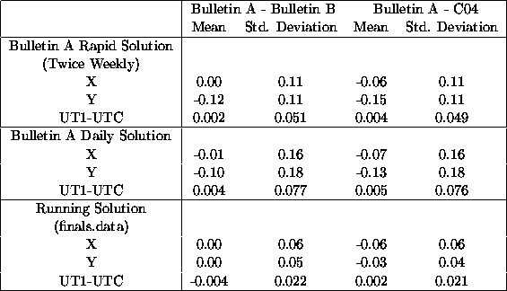
Table: Mean and standard deviation of the differences between the various
Rapid/Prediction Center solutions and IERS Bulletin B and C04 EOP solutions for 2001.
Polar motion X and Y values are in unit of mas and UT1-UTC values are in units
of ms.
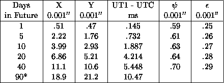
Table: Standard Deviation of the differences between the daily solutions with respect to C04 Earth orientation
solutions for 2001.
![]()
![]() and
and ![]() not predicted 90 days into the future in daily solution.
not predicted 90 days into the future in daily solution.
In recent years, it was determined that the addition of daily Universal Time estimates derived at USNO from the motions of the GPS orbit planes reported by the IGS Rapid service could greatly improve USNO's very near-term UT1-UTC prediction. Now, the IGS estimates for LOD are combined with the GPS-based UT estimates to constrain the UT1 rate of change for the most recent observational day. This greatly improves our UT1-UTC solution at the epoch of the solution and the very near-term predictions. USNO's UT1-UTC predictions were further improved by the addition of AAM-based predictions of LOD excitation (Johnson et al., 2002). For the 5 days prior and after the latest observed day, AAM-based predictions of LOD excitation are combined smoothly with the longer-term UT1 predictions described above.
Recent prediction performance in UT1-UTC has been improved by 42% at 10 days into the future by the addition of a UT1-like data product derived from NCEP AAM (UTAAM) to the combination and prediction routine. This estimate of improvement was determined by examining one year of daily solutions that used UTAAM in the combination and prediction solutions.
Several substantial changes have occurred which affect the performance of IERS Bulletin A. In December of 2000, it was determined that the contributions of the National Centers for Environmental Prediction (NCEP) model estimates of atmospheric angular momentum (AAM) excitation of length of day (lod) were actually degrading the near-term UT1-UTC predictions. Therefore, the contributions of AAM were removed from the Bulletin A solution and the usefulness of the NCEP model to the prediction of UT1-UTC was reevaluated. This reevaluation indicated the presence of quasi-periodic variability in the AAM-derived lod that was not present in the UT1-UTC time series. It was determined that this variability could be reduced and that the resulting AAM-derived lod time series could improve the near-term UT1-UTC predictions (Johnson et al., 2002). Therefore, beginning with 14 August, the AAM-derived lod time series was re-introduced into the combination of datasets used in the solution of IERS Bulletin A.
Starting in May 2001, the number of past data points used to estimate polar motion predictions was changed from 1100 days to 400 days. In 9 October, 2001, the IGS Final EOP file was incorporated in the processing of data. The new file is a concatenation of several originally inhomogeneous segments, all of which have been transformed to be consistent with the ITRF97 realization. For the period since 51601.5 (27 Feb 2000), when the SINEX combination officially replaced the previous orbit combination series, the mean and RMS difference for Bulletin A polar motion are nearly zero and 0.036 mas, respectively, for each component. However, the differences are not entirely random. For the most recent period, the previous difference of about 0.1 mas between IERS Bulletins A and B for PM-y has been reduced almost to zero.
The data available from the IERS Rapid Service/Predictions Center consists
mainly of the data used in the IERS Bulletin. This includes: x, y, UT1-UTC,
d ![]() , d
, d ![]() from NEOS VLBI; x, y, UTC1-UTC, d
from NEOS VLBI; x, y, UTC1-UTC, d ![]() , d
, d ![]() ,
from IAA VLBI; x, y, UT1-UTC, d
,
from IAA VLBI; x, y, UT1-UTC, d ![]() , d
, d ![]() , from GSFC VLBI;
UT1-UTC from NEOS 1-day Intensives; UT1-UTC from SpbU
1-day Intensives; UT1-UTC from GSFC 1-day Intenstives; x, y, UT1-UTC from
GSFC 1-day Intensives; x, y, UT1-UTC from CSR LAGEOS 3-day SLR; x, y from
Delft University of Technology 3-day SLR; x, y from Institute of Applied
Astronomy 1-day SLR; x, y from the Russian Mission Control Center 1-day SLR;
UT0-UTC from University of Texas LLR; x, y, LOD from the International GPS
Service; UT from USNO GPS; UT from NRCanada (EMR) GPS; x, y, UT1-UTC, d
, from GSFC VLBI;
UT1-UTC from NEOS 1-day Intensives; UT1-UTC from SpbU
1-day Intensives; UT1-UTC from GSFC 1-day Intenstives; x, y, UT1-UTC from
GSFC 1-day Intensives; x, y, UT1-UTC from CSR LAGEOS 3-day SLR; x, y from
Delft University of Technology 3-day SLR; x, y from Institute of Applied
Astronomy 1-day SLR; x, y from the Russian Mission Control Center 1-day SLR;
UT0-UTC from University of Texas LLR; x, y, LOD from the International GPS
Service; UT from USNO GPS; UT from NRCanada (EMR) GPS; x, y, UT1-UTC, d ![]() ,
d
,
d ![]() , from the IERS Rapid Service/Predictions Centre; x, y,
UT1-UTC, d
, from the IERS Rapid Service/Predictions Centre; x, y,
UT1-UTC, d ![]() , d
, d ![]() from the
IERS Earth Orientation Center; predictions of x, y, UT1-UTC, from the IERS
Rapid Service/Predictions Center.
from the
IERS Earth Orientation Center; predictions of x, y, UT1-UTC, from the IERS
Rapid Service/Predictions Center.
In addition to this published information, other data sets are available.
This includes: UT0-UTC from JPL LLR; UT0-UTC from CERGA LLR; UT0-UTC from
JPL VLBI; latitude, UT0-UTC from Washington PZTs 1,3,7; latitude, UT0-UTC
from Richmond PZTs 2,6; x, y from CSR LAGEOS 5-day SLR; x, y from Delft 5-day
SLR; x, y, UT1-UTC, d ![]() , d
, d ![]() , from IRIS VLBI.
, from IRIS VLBI.
The data described above are available from the Center in a number of forms. You may request a semiweekly machine readable version of the IERS Bulletin A containing the current ninety days worth of predictions via electronic mail from ser7@maia.usno.navy.mil or http://maia.usno.navy.mil/.
Internet users can also direct an anonymous FTP to maia.usno.navy.mil and change to the ser7 directory where they can access the IERS Bulletin A or more complete databases. World Wide Web access is available at http://maia.usno.navy.mil/.
In addition to being the IERS Rapid Service/Prediction Center, USNO has conducted
collaborative research into the mechanisms of Earth rotation excitation and
has supported efforts of the IERS Global Geophysical Fluid Centers (GGFC). USNO
researcher Thomas Johnson supplied the GGFC's special bureau of the oceans with
his oceanic angular momentum time series, Johnson.01, estimated from the parallel
ocean climate model (Stammer et al., 1996). USNO's research has shown that the
atmosphere, oceans, and continental hydrology all play an important role in
exciting Earth rotation on various time scales, ranging from a few days to a
few years (Johnson et al., 1999, 2001a, 2001b, 2002; Fujita et al., 2002).
The Goddard VLBI group contributed to the study of Earth orientation parameters in the following ways:
1) The Goddard VLBI group investigated the optimization of VLBI observations dedicated to EOP determination using realistic simulations that considered actual antenna/receiver parameters, source strength and unmodeled error. These simulations were used to design the networks and observing schedules for the CORE-A, CORE-B, CORE-3, CORE-1 and R1 sessions that took place in 1999-2002. The last three series used the higher Mark IV sensitivity to improve the precision of EOP over that from the previous NEOS series.
2) Goddard VLBI group has been analyzing VLBI sessions dedicated to EOP determination. Starting from December 2000 these activities were transformed into a service. 24-hour experiments were analyzed within 24 hours after completion of their correlation; 1.5-hour NEOS Intensive experiments were analyzed within 3 hours. Results were automatically uploaded to the IVS Data Centers. The Goddard VLBI group developed the infrastructure and software for smooth data flow from the scheduling centers to network stations, correlators, data centers, and analysis centers.
The Goddard group provided the following analysis products related to the Earth orientation parameters.
Operational series of UT1, pole coordinates, their rates, daily offsets of nutation in obliquity and nutation in longitude obtained from processing 24-hour experiments. Latency: 10-25 days (median latency 16 days in 2002).
Operational series of UT1 NEOS Intensive experiments. Latency: 2-7 days (median latency 4 days in 2002)
Periodic updates of the operational series. All available VLBI data from 1979 were re-analyzed and results were compared with previous submissions and with other series.
3) The Goddard VLBI group undertook research for improvement of VLBI analysis with the aim of improving the EOP series. Members of the Goddard VLBI group made studies in the following areas:
Study of effects of hydrological loading on the estimates of the station position and EOP series.
Study of effects of ocean loading on the estimates of the station positions and EOP series. An empirical model of harmonic station position variations was obtained by fitting the entire data set. It was found that although refinement in the model of ocean loading improved the precision and accuracy of station position determination, the effect on EOP series was only marginal.
Implementation of a new generation of troposphere mapping function based on global numerical weather models.
Investigation of the influence of the a priori models and a priori polar motion series on UT1 series derived from processing NEOS Intensive observations.
4) Members of the Goddard VLBI group investigated the methods of optimal estimation
of nutation coefficients. Empirical nutation expansions were obtained directly
by fitting observations and indirectly by fitting the series of daily nutation
offsets. An empirical nutation transfer function was obtained.
The SYRTE (formerly DANOF) contributed in the following topics.
- Reference systems for Earth rotation. Proposals for parameters to be used in the transformation between terrestrial and celestial reference frames discussed within the T5 IAU Working Group (chair: N. Capitaine), led to the adoption of IAU resolutions (Resolutions B1.7 and B1.8) which recommend the Intermediate Celestial Pole (CIP) as the reference (Capitaine 2000 a,b). These resolutions also recommend the use of the non-rotating origin (Guinot 1979) as the origin of the rotation angle proportional to UT1 as well as the celestial pole coordinates (Capitaine 1990). Expressions for these parameters at the microarcsecond accuracy level have been provided (Capitaine et al. 2000). In Spring 2002, an IERS workshop was organized in Paris Observatory to discuss the implementation of the new resolutions to be adopted on January 2003.
- Modeling of the nutation of the Earth axis. The dramatic improvement of the precision of the VLBI observations allows to estimate the Earth orientation parameters with a sub milliarcsecond accuracy. It was therefore necessary to refine the nutation theory in order to match the observation precision. The new nutation theory (REN-2000) developed for a rigid Earth model by Souchay et al. (1999) has been the basis of the development of the new IAU model MHB 2000.
- Geophysical modeling of the Earth rotation. On time scales ranging from a few hours to a couple of years, most of the variations of the Earth rotation are due to the atmosphere and the ocean variabilities. In order to better characterize the interaction between the solid Earth, atmosphere and oceans, a direct computation of the torque was performed (Bizouard et al. 2000). The angular momentum coupling was analysed (Bizouard & Lambert, 2001). Modeling of short-term nutations due to gravitational tides was derived (Bizouard et al. 2000 a,b) as well as their polar motion representation (Brzezinski & Capitaine 2002). Moreover it has been shown that a resonance phenomenon with specific stationary ocean waves could explain disagreements between both model and observations of diurnal and sub-diurnal variations of polar motion (Zharov et al. 2000). The link between the constraint tensor and Earthquakes in the vicinity of Vrancea in Romania was searched using statistical methods (Souchay and Stavinschi, 1999). Studies of the correlation between Earth rotation and atmospheric variabilities have been developed (Abarca et al., 2000).
- Multi-technique computation of the Earth orientation parameters. The SYRTE contributes to the GRGS Combination Research Center (see IERS report). In this framework, the process of combining normal matrices (Yaya, 2002) leads to a better understanding of systematic errors in the coputation of a combined EOP solution from various astro-geodetic techniques.
- Rotation of Mars and Venus. Using methods similar to those used for the Earth, polar motion relative to Mars was computed (Gauchez and Souchay, 2000) and precise modeling of the precession-nutation of Mars was performed (Bouquillon and Souchay, 1999).
- Operational and scientific activities within international services.
Paris Observatory was selected in the new IERS to host the Earth Orientation Center (head: Daniel Gambis) and the ICRS Center (head: Jean Souchay), the latter jointly with the USNO in Washington. The new structure of the IERS began operation on January 1, 2001.
The scientific activities of the ICRS Center concern the monitoring of the realisation of the ICRF. The stability of the ICRF was analysed by the study of time series of coordinates of radiosources available from USNO. Statistical criteria were proposed to test the time stability of the directions of sources (Feissel et al., 2000). General presentation of the ICRS Center and yearly analyses are presented at: http://hpiers.obspm.fr/icrs-pc/.
General presentation of the IERS Earth Orientation Parameters (EOP), operational activities and yearly analyses are presented in the yearly IERS annual reports (Gambis, 1999 and 2000) and on the web site http://hpiers.obspm.fr/eop-pc. Various statistical methods were analysed (Fernandez et al., 2001) and developed (Bougeard and Caquineau, 1999 and Bougeard, 2001), and implemented for EOP time series analysis (Gambis, 2002). In particular methods based on robust estimators like M-Huber, generalization of both the L1 and L2 class (Bougeard et al, 2000; Gambis et al., 2002), number of studies relative to non-linear analyses and chaos in the Earth rotation (Frede and Mazzega, 1999a, 1999b, Bougeard et al., 2002), specific analyses on the combinations (Gambis, 2000). The essential monitoring of the consistency of both celestial and terrestrial reference frames with respect to the Earth orientation system is essential. It is regularly improving for the different techniques. So far the mean estimated values are about 0.1 mas for polar motion and 20 microseconds for UT1 (Gambis et al., 2002).
The Earth Orientation Center of the IERS at Paris Observatory has the international responsibility to predict and announce a possible leap second to be introduced in UTC. Some communities linked to telecommunication and navigational systems have proposed a revision of the definition of UTC to avoid the discontinuities due to intermittent leap seconds. A survey was organized in June 2002 among Bulletin C (Leap second announcement) and Bulletin D (DUT1) users to know opinion concerning a possible redefinition of UTC. Results of the survey can be found on http://hpiers.obspm.fr/eop-pc.
Paris Observatory is an Analysis Center of the IVS (head: Anne-Marie Gontier) since the beginning of the IVS. The package GLORIA was developed to process VLBI data and also to contribute to the activities of the ICRS center. A primary data Center was also implemented (head: Najat Essaifi) and is operational. It automatically performs the collect of VLBI data with a similar organization that those implemented at the BKG in Germany and the CDDIS in USA. Paris Observatory is moreover hosting an analysis Center of ILRS for Lunar laser ranging (head: Jean Chapront). Analyses of observations derived by LLR from McDonald Haleakala and CERGA allowed to fit the orbital elements of the Moon and the Earth-Moon barycenter, free libration, secular deceleration due to tides and the positions of the reflectors in a selenic reference frame. The processing also led to the determination of the orientation of the dynamic system with respect to the ICRF and also an estimation of the precession constant.
- Organization and co-organization of the "Journées Systèmes de référence spatio-temporels" with several sessions devoted to Earth rotation:
- in 1999 by M. Soffel and N. Capitaine in Prague, Dresden, Germany
- in 2000 by N. Capitaine in Paris
- in 2001 by V. Dehant and N. Capitaine in Bruxelles, Belgium
- in 2002 by M. Stavinchi and N. Capitaine, Bucharest, Romania.
Individual contributions can be additionally mentioned as, for example, from R. Vicente, who investigated (2000) the needs to adopt a consistent set of reference systems and models and for the employment of adequate statistical methods for the analysis of the observations, taking into account the peculiarities of the motions of the Earth (Vicente & Wilson 2002). S. Debarbat developed historical studies on the theory and observations of Earth's rotation.
All the contributors to this report from IERS, IVS and various institutes involved in Earth rotation studies are sincerely acknowledged.
Nicole Capitaine
President of the Commission